
Study of the Matthew and Hunter zone
Geological context
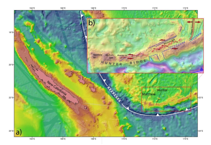
Matthew and Hunter Islands are the only emerged parts of the long submarine rift, called the Hunter Rift, made up of the alignment of numerous volcanic landforms. This rift developed at the southern end of the New Hebrides subduction zone, first along a strike-slip zone, then as a proto-arc resulting from the initiation of a new subduction zone 2 million years ago. This tectonic-volcanic environment is completed by the southward propagation of a back-arc oceanic accretionary ridge that tears through the volcanic rift and is inserted into it.
The result is a highly original geodynamic context that sees the coincidence of an oceanic accretionary rift and a subduction volcanic arc. This area is the only known example on Earth where the initiation of a subduction zone has been studied.
Scientific objectives
Volcanology and geophysics
The vast majority of submarine volcanoes are not monitored despite the associated risks. The South West Pacific region is particularly rich in submarine volcanoes, with little capacity and funding for monitoring. Like Mayotte, one of the objectives of the Matthew and Hunter observatory would therefore be monitor volcanic activity. The Matthew and Hunter zone is relatively remote from any inhabited area, so the risks associated with seismic activity are very low. However, there is an induced tsunami hazard that could be of concern to New Caledonia and Vanuatu but also to territories as far away as New Zealand. The following activities could be developed via ScInObs to for the monitoring of underwater volcanoes:
- Innovative mooring systems, which are cheaper than cabled observatories, relatively easy to deploy and redeploy in other areas of interest, could be particularly useful.
- Measurement of elemental flows from the ground to the water column (hydrothermal fluids) and from the water column to the subsoil (sedimentation)
- Similarly, the deployment of hydrophones would make it possible to monitor sound emissions linked to volcanic activity, hydrothermal sites, but also those from the biosphere (cetaceans, fish and hydrothermal site ecosystems) and finally human activity (fishing, tourism, mining industry...).
- These moorings could be associated with a benthic station to monitor crustal deformation (geodesy and seismology): Pressure/tilt sensors, accelerometers, OBSs, and thus feed the tsunami warning networks.
Biology
- Monitoring of hydrothermal ecosystems
- Colonisation of newly created substrates
- Larval colonisation of various substrates
Physical Oceanography
- Effect of topography on ocean circulation
- Local hydrodynamic disturbances and consequences on transport, dispersion of inert and biological particles, soil/water column flows, fertilisation of water bodies
- Link between seismic activity and tsunami